2018 School Spending Survey Report
How To Boost Spatial Skills, Key to STEM Learning
A school librarian develops exercises to foster spatial reasoning, prepping students for future success.
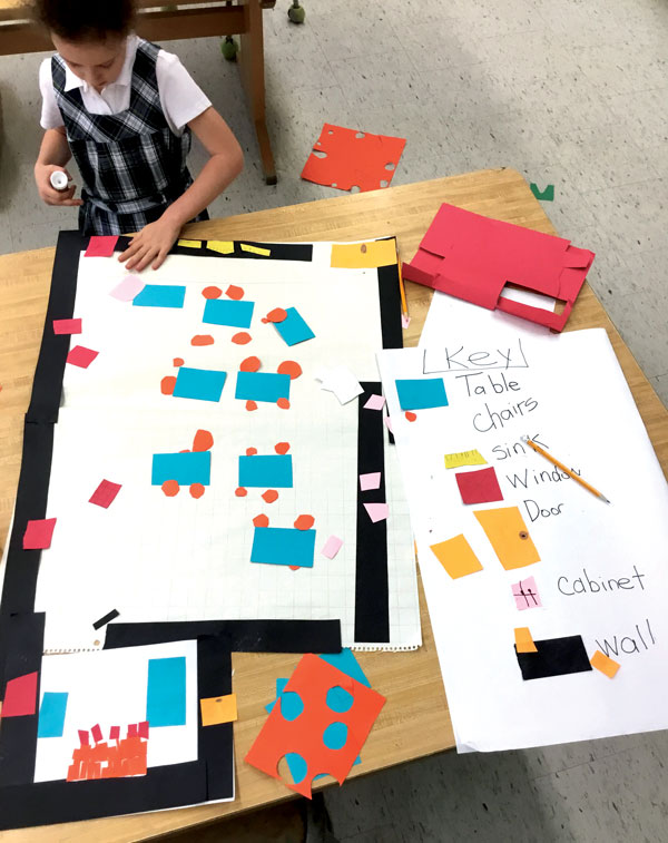
Students at the Columbus School for Girls create a
representational map of the classroom with a color key.
Photos by Linda Swarlis
Teaching database instruction in my high school library, I was puzzled when some students could find important information on a computer screen quickly while others struggled. They appeared to view the same computer screen very differently, though none had a documented learning difference. So I began investigating that mystery as part of my doctoral research from 2004 to 2008. I found that the connection between spatial skills and success in STEM fields was well documented, but that research was not being applied.
While the popular belief is that spatial skill or ability is fixed, researchers have proven this to be a myth. These skills can improve and stay improved. I drew from research to create ways to boost them among my students and also created a LibGuide with ideas and resources. Spatial skill is the ability to rotate and manipulate objects in one’s mind and understand the relationships among objects in space. It is nonverbal. Estimating distances is a spatial skill, as are visualizing DNA or chemical structures, constructing roads or bridges or houses, and interpreting ultrasound images. Almost every STEM discipline emphasizes spatial skills, including astronomy, geology, geography, meteorology, physics, surgery, and computer science. One of the easiest ways to understand spatial skill is to look at a map and try to approach your destination from another direction than south to north. Do you rotate the map, or can you visualize your route by turning the map in your mind? Do you enjoy complicated puzzles, including three-dimensional ones? If you play games that have spatial components like chess or Battleship, can you visualize the board in your mind and see your next moves? Can you construct furniture or LEGOs easily and build complex structures with blocks? All these activities rely on spatial skill. If students’ spatial skills reach certain baseline levels, they can succeed in engineering, according to research by engineering professor Sheryl Sorby. If not, students aren’t able to complete engineering coursework. However, training permanently improves skill levels, allowing those students to move forward. You may have noticed your low spatial learners in the classroom when you ask them to interpret graphs. They tend to view graphs literally rather than as a representation, and they find it difficult to find salient information. Everyone can improve their spatial skills, but it takes awareness and practice. In addition to puzzles and building projects, games such as Tetris and chess can have an impact.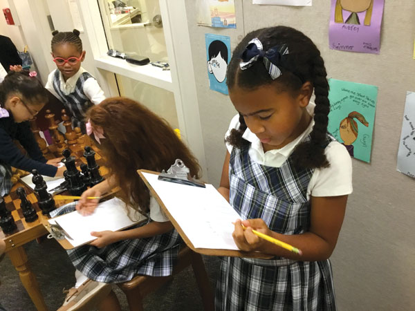
Students create maps of school hallways, which collectively form
a plan of the whole campus.
Ditch GPS
What steps can school librarians take to remove this barrier to the STEM pipeline for our students? You can make a difference through simple interventions. First, at every opportunity, include work with maps, globes, and atlases. While GPS systems are ubiquitous and assist with our immediate need to find our way in space, they impair our larger sense of place. Ask students to locate the sites of stories you share or historical events they are studying on the map, globe, or atlas. Have them physically face the direction of the city, state, or country being studied.
Practice directional language
Using spatial and directional language builds spatial skill and students’ sense of place. Post cardinal directions—north, south, east, and west—on every library wall, and ask students to orient themselves: “Face east”; “Use the west door when you go to recess”; “Meet me at the north end of the playground or the gym.” Ask teachers to post cardinal directions in classrooms, hallways, and doors and to use these terms with students. Have students orient themselves in school using cardinal directions.
Encourage students to note cardinal directions as they travel to and from school daily. Purchase or get free maps of your geographical area and your school. Have students locate their homes and local landmarks on a map. Ask them to notice where the sun rises and sets when they are home and at school, and which direction their front door faces. On field trips, have them map out the route and follow it while traveling.
Geometric shapes and picture books
In addition to spatial language, describing and locating geometric shapes also strengthens these skills among preschool and elementary children. Use spatial terms to describe position in space—such as above, below, behind, far, and near—and use precise words to describe geometric shapes. Displaying geometric shapes in one color works best for recognition. You can also use picture books to support spatial language building and map use.
In this increasingly cognitively complex world, we can make a real difference for our students who may need us to help them reach their full potential in this area. Let’s get them up to speed so they can all go on and do great things.Add Comment :-

Added To Cart
RELATED


RECOMMENDED
CAREERS
The job outlook in 2030: Librarians will be in demand
CAREERS
The job outlook in 2030: Librarians will be in demand
ALREADY A SUBSCRIBER? LOG IN
We are currently offering this content for free. Sign up now to activate your personal profile, where you can save articles for future viewing
ALREADY A SUBSCRIBER? LOG IN
Thank you for visiting.
We’ve noticed you are using a private browser. To continue, please log in or create an account.